This map was created for friends of the Pod Pueblo Planning for their planing work with Metro. They wanted to show, simply, what transit lines the attendees of their focus groups (women riding transit in LA) used. I created a map that fit in with Metro branding for their client, Metro, and also displayed the needed information quickly and easily.
Retrace the routes of Bilbo, Frodo and Sam in your morning commute by using the Middle Earth Transit Authority system map. Connecting the four corners of Middle Earth, the META also offers convenient connections to the Straight Road Ferry, Gwaihir SkyTram, and Arda Rail. So from Forochel to the Poros, and from Dorwinion to the shores of Belegaer, use META today!
I worked on this map right after I finished my Metroros map in the winter of 2012. I must’ve been unemployed or something. Given that J.R.R. Tolkien was British, I thought that a certain city’s tube map would be a nice place to start from design-wise.
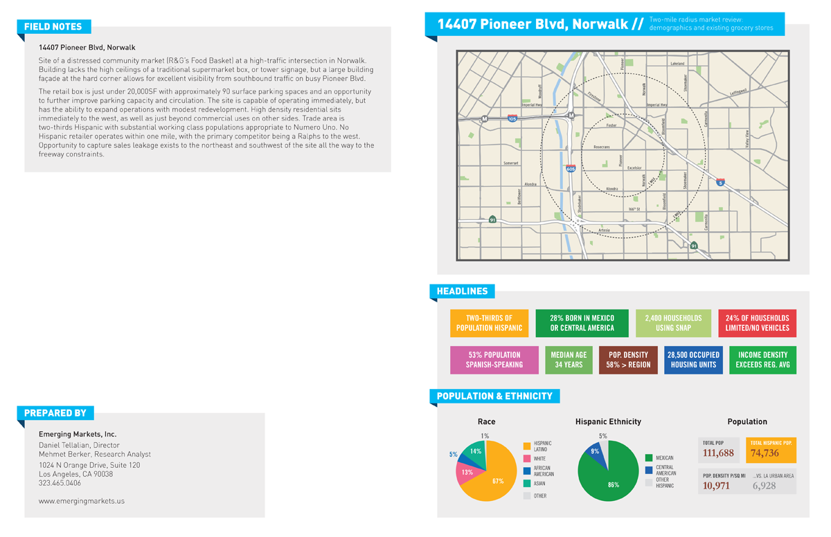
These maps were done in the spring of 2012 for Emerging Markets, Inc. They show portraits of the Hispanic communities of LA County. They were used to inform financial and grocery industry clients.
I was contacted by the Institute of Transportation Studies at UCLA (UCLA ITS) to design a report they authored on Tactical Transit Lanes, which are transit lanes which are tactically implemented to improve ridership.
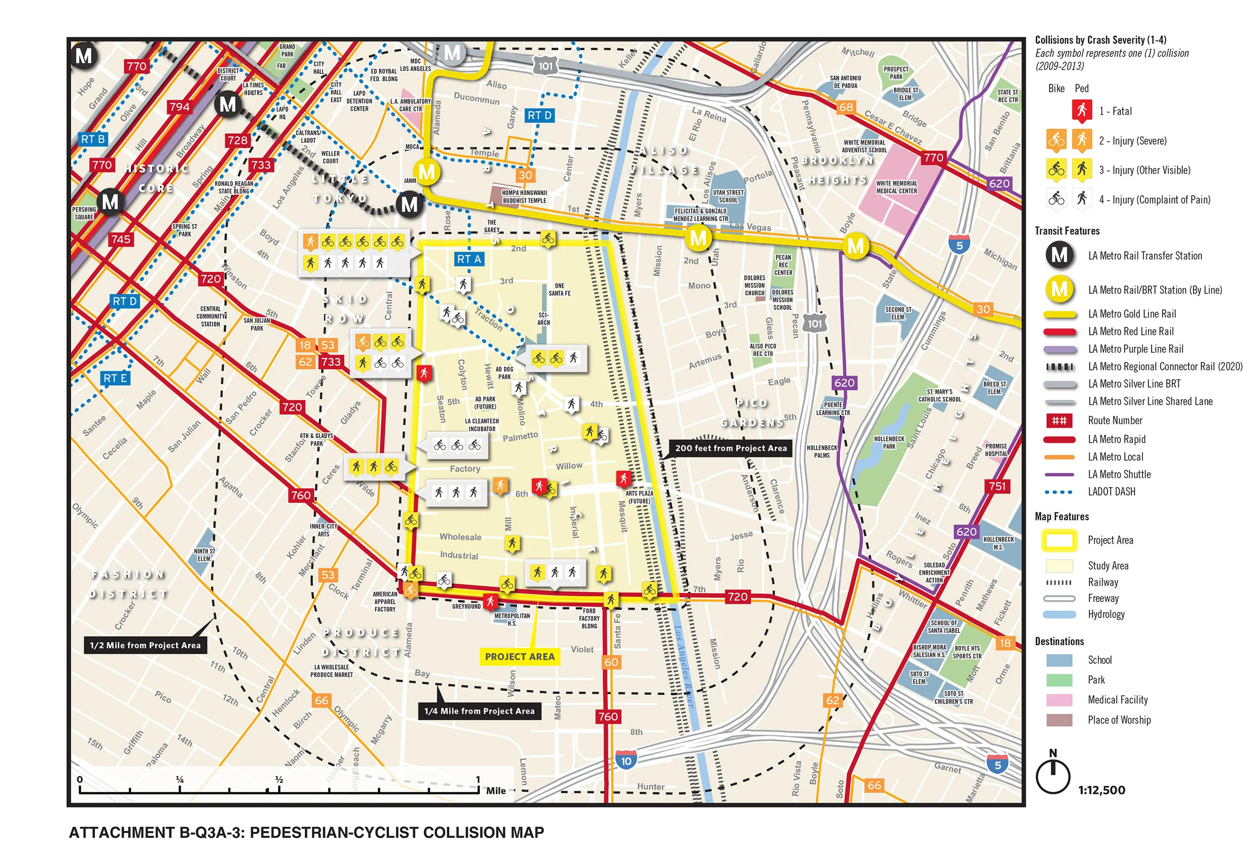
For the first two rounds of the California Transformative Climate Communities program grant funding, I’ve had the pleasure of working with Deborah Murphy Urban Design + Planning. Our team has won $58 million for the communities of Watts and the Northeast San Fernando Valley. These applications involve lots of different component projects, so the project maps can get pretty packed.
I have helped Deborah Murphy Urban Design + Planning craft winning grant applications for public agencies for three cycles of the California Active Transportation Program by making maps and conducting research for the team. I’m really proud of this work as our team, led by Deborah, has secured over $36,970,200 for four project over three grant cycles.
We try and give as much context as possible in our maps for the application reviewers, and I think we do a pretty good job!
Was overjoyed to help my dear friend Lindsey Kiner by developing a visual identity for her new consulting firm, LK Planning.
Lindsey wanted to highlight her expertise in transportation as well as highlight her strengths in communication. I suggested the “LK” monogram for a primary logo, and we think it works well. She’s a killer, so any small part I can do to help out is awesome in my book.
This map was made for Avivar Capital for some of its work in New Mexico. It shows the tribal lands of the tribes they were working with along with the dominant industries in pertinent New Mexico counties.
I did this representation of possible redesigns for 6th St in the Miracle Mile for a bike plan for the area. It shows three different possible treatments.
I did the layout for this report in the fall of 2012. The report was written by Daniel Kurz and has to deal with banking development districts, a new effort to address the lack of mainstream financial services in underserved neighborhoods. The report was commissioned by The California Endowment, and we wanted to give them a product they could publish if they so chose.
This map portrays the results of an analysis done to determine target areas for the FreshWorks FEMI microloan program in 2014. Using a custom index of preferred socioeconomic indicators, the analysis gave a starting point for the team at Emerging Markets, Inc. to spring from in creating the program.
A collection of various covers which I created for reports produced by Emerging Markets, Inc. for various clients.
I helped researchers at the Fed and Colby College with a project that involved many different GIS tasks. I helped them by digitizing a 1921 zoning map and spatially joining the historical zones with a modern dataset. In addition, I built them an historical address locator, using historical street networks for 1900, 1915, and 1930 that I developed by taking current centerline data and adding/editing segments to reflect their existence and name for the three aforementioned years. I sued Sanborn maps and other historical sources to both draw historical streets which no longer exist and to add historical “to” and “from” addresses for all street segments for 1900, 1915, and 1930.
For the 2015 edition of Footnotes, the Los Angeles Walks newsletter, I put together the counts of people walking taken during the 2013 LA Ped+Bike Count for a couple of maps.
This is a map originally made in 2008 which tells the story of the East African theater in World War I.
Unlike the Western Front in Europe and its war of attrition, the campaign in East Africa was a war of mobility and guerrilla tactics. It was a uniquely colonial war, with the German forces composed of local Africans commanded by German officers, and Allied forces composed of, initially, Indian, Baluchis, and Boer and English South African troops, and later the King’s African Rifles, black Africans recruited from East Africa.
Tropical diseases and overwork and exhaustion caused far more casualties than bullets.
After the initial Allied assault on Tanga failed, the German commander, General Paul von Lettow-Vorbeck, harried and raided British East Africa for the following two years as part of his strategy to get the Allies to expend as many men and as much resources as possible to keep them from fighting in Europe. With all of Germany’s other African colonies having capitulated to the Allies by the beginning of 1916 however, the British launched an invasion of German East Africa which the Germans could not withstand. For the next two years, von Lettow-Vorbeck would lead the Allied forces on a wild goose chase through the mountains and jungles of modern-day Tanzania and Mozambique, only surrendering after hearing of the armistice being signed in Compiegne.
A dear friend of mine asked me for a map for her wedding. I kept it simple, but added some Oaxacan colors (you should've seen the first version!), and pixelated icons to reference her and her fiance's love of old school video games.
I worked on this project just out of college, and I wanted to make a graphic which I felt could go in a NY Times story. Countries are sized by their number of Guantanamo detainees.
These maps were done for Kinecta in the summer of 2012. Kinecta is a credit union, and it had recently acquired Nix Financial. I mapped out the Nix locations by type for Kinecta’s board of directors, and also made a map of important commercial corridors on the East Side of LA and the Gateway Cities.
This scratch pad was designed for the LA River Revitalizations Corporation’s annual board retreat. It highlights some locations of importance along the river, including the LA River Bike Path and a parcel of special interest to the LA River Corp.
With so many places to go and things to do in the Seven Kingdoms, Westerosi are discovering the great value of riding Metroros. Whether it's a tournament at Harrenhal, a visit to Planky Town, a semester at The Citadel, or a life-long sentence at the Wall, go Metroros and go faster!
I originally created this map in the fall of 2012. I had a blast making it as it was just a glorified excuse to pore over maps of Westeros for hours. I think Angelenos can tell where I got my idea for the style from.
As part of my work with Ramsey County Parks & Recreation back in 2010, I had to create some new symbols for certain recreational facilities which our parks had, but didn’t already exist in some other symbologies. So, I combined symbologies from the National Park Service, Minnesota DNR, and Three Rivers Park District with original symbols I created to produce a Minnesota Recreation Symbols set.
We turned it into a typeface, and shared it with all the participating Minnesota agencies for their use.
I have an unhealthy enchantment with the Byzantine Empire. I say unhealthy because it’s so excruciating to read about the Byzantines anytime after the Comnenoi really--it’s just a long slow slog until 1453 with a short Latin Crusade thrown in. The thing is though, that the 14th and 15th centuries were periods of intense artistic creativity for the Byzantines, and when the Turks conquered Constantinople, the scholars of the Empire who moved to Italy helped in part to spark the Renaissance. Can you really think of the Byzantine Empire then in terms of dead and dying?
I thought about that and I thought about the fact that any polity that has existed on earth is bound to have some effect on history, and consequently on the present day. So I thought pretty pictures would do to help give these expired nations their time in the sun.
In the summer of 2014, Emerging Markets, Inc. helped Northgate evaluate its new store at the newly-constructed Juanita Tate Marketplace on Central and Slauson in South LA and at its store in North Long Beach. We showed them neighborhood profiles for different metrics which were important to them.
These are examples of market reviews done for Numero Uno Market. I created this house style for Emerging Markets, Inc. to use with its supermarket clients in analyzing site locations.
These maps were made to help Primestor assess the Baldwin Hills Crenshaw Plaza in relation to the rest of South LA and the surrounding communities. Specifically they wanted to see what the growth of the Hispanic population might look like, so I included projection numbers.
These maps were made using orthophotography to show Ramsey County residents what to expect at the various Ramsey County Off-Leash Dog Areas.
I redid all the Ramsey County Parks & Rec maps while I was there. Specifically, they were updating to a new website in any event, so I just slipped in and replaced all the existing maps with redesigned ones that matched the Parks department’s new style guidelines.
These maps were done in 2009 and labeled states based on their corresponding export rates with various countries around the world. I like these, I think they really make it clear how big and important the economies of states like Texas and California are, while at the same time showing interesting differences between states.
This map was made to show the results of the creation of the Pedestrian Facilities feature class for Ramsey County. I did a lot of the GIS work to get this feature class ready for prime time. It basically shows sidewalks and separated trail facilities.